Introduction

What is MapAble®?
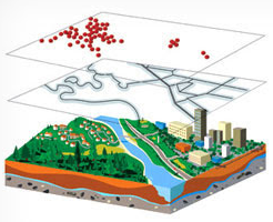
MapAble® exist to simplify the complexity of information through a user friendly mapping and visualization interface. We bring cloud based GIS functionality and data together into a unique system that will satisfy the curiosity of the occasional user to the high level needs of the professional planning teams collaborating across continents.
We all use and explore maps for two reasons; curiosity and a need to satisfy information needs. The general level of complexity and cost of Geographic Information Systems (GIS) and web base mapping applications, put this powerful tool outside the reach of ordinary people and non-GIS professionals alike. However, the increasing need to be able to spatially manipulated and visualize data independent from a GIS professional, created a need to provide a tool that meets the day to day mapping requirements of both ordinary people and professionals. MapAble® addresses this need in a simple and affordable way.
MapAble® allows you to:
Access data from a comprehensive database of data in the public domain within South Africa.
Load data from the data base and your own data and render it on a range of base maps from which you can choose
Do area, line and point queries and report on the results
Collaborate globally in real time in teams on a workspace and share information and mapping results
Embed links in reports or e-mails to communicate and show mapping results in a browser to non-team members and team members alike
MapAble® frees the hand of the GIS specialist in your organization to focus on his tasks and empowers the non-GIS user to do spatial analysis and show the results thereof.
Features
MapAble® has a wide range of features. These features distinguish MapAble® from other related products. As MapAble® develops, these feature are continuously refined and extended. (Watch this space!)
Mapping
-
Cloud based mapping platform
-
Multi-format inputs
-
Web Map Service (WMS and WFS) enabled
-
Can accommodate any standard projection
-
Onscreen drawing and annotations
Integration
-
Data theme integration
-
Prepared and packaged data sets of South Africa (currently more than 260 national data sets included and ready for use by subscribers)
-
Cross sectoral data platform
-
Ability to related information from various sources
Collaboration
-
Cloud based access from any point
-
User access control with different access levels
-
Feedback to project loop for managing team inputs and queries
-
Real time collaboration updates
-
Map notes which enables scalable online annotations and mark-ups.
-
Save annotations for later use
-
Share to mail, save to Dropbox, etc.
-
Embed browser links of maps in documents
-
Export maps in png-format and as pdf-files
-
On-the-Fly Geo-design which will allow for the development and capturing of planning proposals in workshops and team or client meetings
Visualization
-
Publishing tools
-
Style pre-sets with full user customisation
-
Large number and range of icons available and add your own according to your needs
-
Layout template for easy styling and printing
-
Dynamic legends
-
Embed dynamic map in a website
-
Embed browser links of maps in documents, e-mails, presentations. etc.
Dynamic Analysis
-
Thematic mapping
-
Spatial characterization
-
Data partitioning
-
On-the-fly cross layer analysis
-
Extended query toolbox
-
Cross sectoral data profiling and reporting
-
Custom reports
-
Spatial correlation