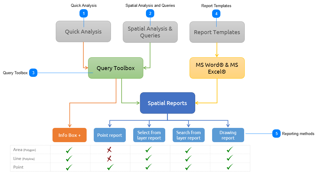
Spatial Report is the functionality which makes MapAble stand out against other similar spatial software packages. Spatial reports brings together the rich data content, analytical methods and ease of use to remix the traditional GIS functions into a powerful information and productivity tool.
The Spatial Analysis functionality lets the user run a series of small spatial analysis procedures between various data layers and publish the results in highly professional customisable reports. The following section gives an overview of the main components of the Spatial Report functions:
 Quick AnalysisThe Quick Analysis is a very fast but effective way for the user to calculate the spatial relations of a specific layer with that of other layers in the workspace. The user can ADD to the existing attributes in the INFO BOX by adding analytical procedures or queries that will add the result into the INFO BOX, thus creating what we call an INFO BOX+.
|
|
For a more detailed description on Quick Analysis, please go to the Quick Analysis section
| |
 Spatial Analysis and QueriesThe Spatial Analysis and Queries functions let the user create a Query List with a range of analytical procedures or queries. All the queries in the list, form the base inputs to a report that can be run from any similar type of spatial feature (e.g. polygon. line or point). An example may be a Demographic Profile of an area which executes a range of queries to describe the demographic characteristics from the various available layers.
|
 Query ToolboxThe Query Toolbox consist of a range of analytical procedures which the user can use to create new information to feed into the spatial reports. These procedures are typical GIS functionality which any GIS software package have (or at least should have). This range from normal Drill down on Point queries to more sophisticated Data Partitioning.
|
|
For a more detailed description on the Query Toolbox, please go to the Query Toolbox section
| |
 Report TemplatesReport template are created in any external software packages that can export the template to the HTML format. In the South African context, the use of the two popular Microsoft® product; MS Word® and MS Excel® are easy choices. This manual will describe how to create a Report Template using these two software packages and how to import them into MapAble.
|
|
For a more detailed description on the creation of Report Templates, please go to the Report Template section
| |
 Reporting methodsOnce a Spatial Report is set up, there are various ways of executing them. They are always based on a specific STUDY AREA. Study areas can be selected in various ways, and once a study area is selected, Spatial Reporting can be done on them.
All the methods apart from the Info Box+, have the same reports available for executing.
|
|
For a more detailed description on the methods of executing a Spatial Report, please go to the Reporting methods section
|
|
|